Soil Monitoring Lower Austria
Soil Condition Inventory
At the beginning of the 1990s, a soil condition inventory was carried out for the first time in Lower Austria to record general soil parameters at a total of about 1450 sites. Since, based on the relevant scientific literature, it can be assumed for most of the soil properties recorded in the BZI that changes only occur gradually over long periods of time and can thus be statistically validated, a re-sampling was planned for longer time intervals. This started after 30 years at the beginning of 2020. Currently, topsoil samples are resampled at 300 locations in the Pannonian region (Chernosem region) and examined for the characteristic values of organic carbon, nitrogen, selected metals and metalloids. The evaluation opens up the possibility to identify changes in the investigated parameters over the last 30 years.
Repeat sampling of soil mapping sites in Lower Austria
In the period 2016-2019 >600 profile points of the Austrian soil mapping in Lower Austria were sampled again. Top soil samples were taken from cropland and grassland locations for which archive samples from the initial sampling are still available. The investigations include soil acidity (pH-value), carbonate, organic carbon and nitrogen, as well as nutrients that are potentially available to plants (phosphorus, potassium and silicon).
Mapping and modelling of carbon saturation potentials and deficits
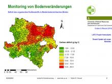
Based on the BZI Lower Austria, the saturation potentials were derived from the grain fraction <20 µm (clay, fine and coarse silt) using model calculations and GIS-based interpolation for the whole of Lower Austria with the help of a landscape model in high resolution. Furthermore, the saturation deficits were calculated from the difference to the organic carbon contents collected in 1990 and also converted into a high-resolution map by means of a landscape model.
Soil monitoring and monitoring of organic pollutants in Lower Austrian soils
In the central settlement and economic areas of Schwechat and Tullner Feld, a total of >50 soil monitoring plots have been set up since the end of the 1990s according to the concept of Blum et al. (1996), some of which have been sampled several times. The measured parameters include pH values, organic carbon and carbonate as well as inorganic (heavy metals and metalloids, fluorine) and organic (PAH, dioxins and furans, BTEX, PCB) pollutants. As part of the Austro-PoPs project, some of the areas were sampled again in 2019.
04.11.2025
EUSDR PA10: 12th Danube Participation Day in Sarajevo
more ...30.10.2025
Online-Präsentation BBK-Projekt CNSoil - Zwischenergebnisse
more ...07.10.2025
CatchHedge - Potenziale von Hecken im Zeichen des Klimawandels
more ...16.+17.09.2025
32nd Conference of the Danube Region
more ...12.09.2025
Grundlagen der professionellen Bio-Mandel-Produktion
more ...10.09.2025
Agroforst u. Marktgärtnerei, Symbiose
more ...05.09.2025
Regionales Wiesensaatgut gewinnen mit dem Wiesensamenernter
more ...25.06.2025
Feldtag - StripTill im Bio-Mais im Trockengebiet
more ...25.06.2025
Seminar: Wildbienen- und Nützlingsförderung im Biolandbau
more ...24.06.2025
BOKU Green Plate Forum 3.0
more ...24.06.2025
Die Maulbeere - Kultur, Produktion u.Verwendung
more ...17.06.2025
Frühjahrstagung Österr. Gesellschaft für Agrar- und Umweltrecht (ÖGAUR)
more ...13.06.2025
Seminar: Artenvielfalt in Ackerbauregionen fördern
more ...03.06.2025
Seminar: Keine Angst vor der Ackerdistel
more ...03.06.2025
Agroforstsysteme: Anbau-Modelle der Zukunft
more ...20.05.2025
IDM-Generalversammlung 2025
more ...15.05.2025
Seminar: Unkräuter/Beikräuter erkennen und als Zeigerpflanzen nutzen
more ...13.+14.05.2025
Bodenforum Österreich - Frühjahrstreffen
more ...04.05.2025
Tageskurs: Perma-Veggies - Mehrjähriges Gemüse und essbare Stauden
more ...03.05.2025
Waldgärten-Exkursion
more ...


