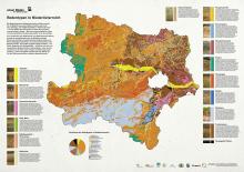
Soil types in Lower Austria - the 20 NÖ district soil maps
A team consisting of representatives from the University of Natural Resources and Life Sciences (Prof. Walter Wenzel), the Federal Office for Water Management (Dr. Peter Strauss, Dr. Rosemarie Hösl) and the Federal Office for Forestry (E. Leitgeb, G. Aust, M. English) in 2012, from the data of the Austrian Soil Map 1: 25.000 and other sources, a comprehensive soil map for Lower Austria was presented for the first time, which takes into account not only agricultural soils but also forest soils.
Now this card was edited under the direction of Dr. Peter Strauss for all districts of Lower Austria and supplemented with additional information and typical floor pictures.
On October 13, 2016, Prof. Walter Wenzel presented the District Soil Maps for the first time as part of the agricultural district directorial conference at the University and Research Center Tulln (UFT). Using the example of the soil map of the district of Tulln, Prof. Wenzel was able to explain the importance of our soil resources for sustainable development and pointed to the versatility of the district soil maps commissioned by the agricultural district authority of Lower Austria for raising awareness and informing citizens.
Below you will find the general explanation, the individual district soil maps, as well as the NÖ soil map as pdf-files for download:
District Amstetten & Waidhofen an der Ybbs
District Mödling and Vienna Area
District Neunkirchen, Wiener Neustadt and Wiener Neustadt Land
District St. Pölten and St. Pölten Land
District Waidhofen an der Thaya
04.11.2025
EUSDR PA10: 12th Danube Participation Day in Sarajevo
more ...30.10.2025
Online-Präsentation BBK-Projekt CNSoil - Zwischenergebnisse
more ...07.10.2025
CatchHedge - Potenziale von Hecken im Zeichen des Klimawandels
more ...16.+17.09.2025
32nd Conference of the Danube Region
more ...12.09.2025
Grundlagen der professionellen Bio-Mandel-Produktion
more ...10.09.2025
Agroforst u. Marktgärtnerei, Symbiose
more ...05.09.2025
Regionales Wiesensaatgut gewinnen mit dem Wiesensamenernter
more ...25.06.2025
Feldtag - StripTill im Bio-Mais im Trockengebiet
more ...25.06.2025
Seminar: Wildbienen- und Nützlingsförderung im Biolandbau
more ...24.06.2025
BOKU Green Plate Forum 3.0
more ...24.06.2025
Die Maulbeere - Kultur, Produktion u.Verwendung
more ...17.06.2025
Frühjahrstagung Österr. Gesellschaft für Agrar- und Umweltrecht (ÖGAUR)
more ...13.06.2025
Seminar: Artenvielfalt in Ackerbauregionen fördern
more ...03.06.2025
Seminar: Keine Angst vor der Ackerdistel
more ...03.06.2025
Agroforstsysteme: Anbau-Modelle der Zukunft
more ...20.05.2025
IDM-Generalversammlung 2025
more ...15.05.2025
Seminar: Unkräuter/Beikräuter erkennen und als Zeigerpflanzen nutzen
more ...13.+14.05.2025
Bodenforum Österreich - Frühjahrstreffen
more ...04.05.2025
Tageskurs: Perma-Veggies - Mehrjähriges Gemüse und essbare Stauden
more ...03.05.2025
Waldgärten-Exkursion
more ...


